About Total Station Cadastral Survey
Total Station Cadastral Survey Apps is designed to assist Land Surveyors to perform Cadastral Surveying. Features in this Demo version: 1. Measurement using CL or CL and CR (circle left & circle right). 2. Adding Station...
Total Station Cadastral Survey Apps is designed to assist Land Surveyors to perform Cadastral Surveying.
Features in this Demo version:
1. Measurement using CL or CL and CR (circle left & circle right).
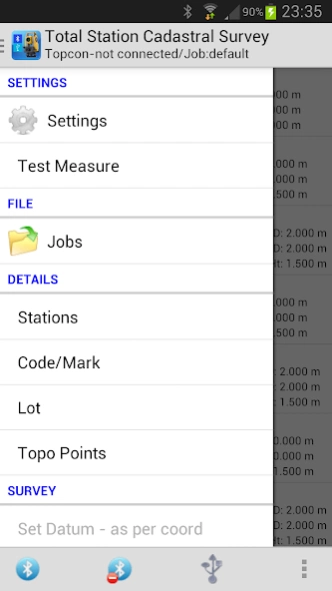
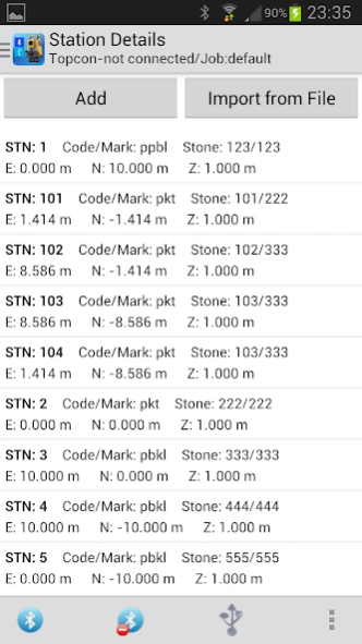
2. Adding Station for survey or start of survey.
3. Using/Adding Code/Mark.
4. Defining Lots or Land Parcel.
5. Measuring Topo Points.
6. Stake Out.
7. Survey Data Observation view and Survey 2D Map View.
8. Export Observation Data to GTS7 and CSV file formats.
9. Export Stations Data to Coordinates XYZ file format
10. Export Topo Points and Lot Information to CSV file format.
11. Backup/ Restore to XML file format.
12. Create Points by Point Offsets, By Line Offsets and by Line intersect.
13. Resection - 2 Points (http://www.csbe-scgab.ca/docs/journal/29/29_1_93_raw.pdf)
14. Resection - 3 Points, Tienstra's Method (http://www.raeng.org.uk/education/diploma/maths/pdf/exemplars_advanced/10_resection.pdf)
Connectivity:
1. Bluetooth
2. USB Serial Adapter Cable. Please refer to https://www.facebook.com/systranovasoftware on the use usb serial connection.
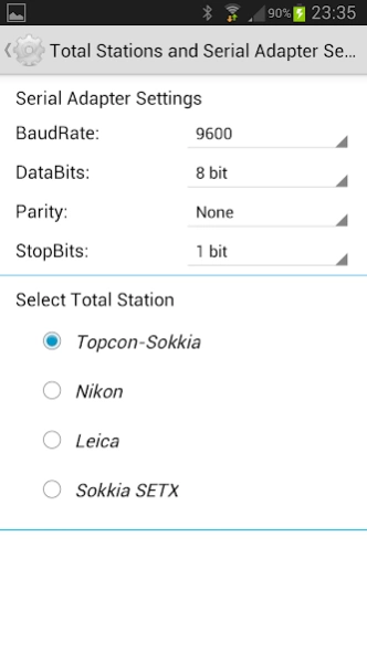
Supported Total Station:
1. Topcon. including Topcon-Sokkia and Topcon-Gowin.
2. Nikon
3. Leica
4. Sokkia SETX
5. Pentax (setting Horz Angle, please use keypad on Pentax total station)
Supported Languages:
1. English.
Future Plans:
1. To have more Languages support.
2. To have measurement method measuring "Point On Line".
3. To have measurement method measuring "Produced Line".
Cadastral Survey methods are different from country to country due to regulation, users who are interested are encourage to submit their comments and ideas to
[email protected].
Thank you.
Previous Versions
Here you can find the changelog of Total Station Cadastral Survey since it was posted on our website on 2019-11-09 10:16:56.
The latest version is 2.1.1 and it was updated on 2024-04-19 18:27:05. See below the changes in each version.
Total Station Cadastral Survey version 2.1.1
Updated At: 2014-11-23
Changes: v2.1.1
Minor Bug Fix
v2.1.0
Added Pentax Interface.
v2.0.9
Updated Leica Interface.
v.2.0.8
Added Resection 2 points and 3 points.
v2.0.7
Minor Bug Fixes.
v2.0.6
Bug Fixes.
v2.0.5
Minor Bug Fix.
v2.0.4
Added Export XYZ Coordinates file. XYZ File Format can be set in settings.
v2.0.3
Optimized for 7in Tablet.
v2.0.2
First Release.
Disclaimer
Official Google Play Link
We do not host Total Station Cadastral Survey on our servers. We did not scan it for viruses, adware, spyware or other type of malware. This app is hosted by Google and passed their terms and conditions to be listed there. We recommend caution when installing it.
The Google Play link for Total Station Cadastral Survey is provided to you by apps112.com without any warranties, representations or guarantees of any kind, so access it at your own risk.
If you have questions regarding this particular app contact the publisher directly. For questions about the functionalities of apps112.com contact us.